Posts Tagged With: lava

Oo-Ee-Oo A’a

There are many things that one finds in abundance on the Big Island. One of these is lava, which comes in a variety of forms, the two most common being pahoehoe, which is the fast-flowing, smooth ropy stuff, and the other being a’a, which is very sharp-edged, porous, and clinkery. A’a looks like this:

Another common sight on the island is kiawe trees, which is an invasive species related to the, um…. actually I neither know nor care what it is related to. My main point of concern is its very nasty thorns, thus:

I mention all this because both entities copiously occupy this spooky hiking trail that leads one to a field of petroglyphs, about which I have written before:

Why do I mention all this? Because yesterday afternoon, whilst hiking along this very trail, my dumbass self tripped on a root, or a rock, or a poltergeist, or something, and fell through a knot of kiawe branches and onto a pile of a’a rocks. It was a pure Wile E. Coyote-vs-Roadrunner moment, laying on the ground looking like a rock-encrusted pincushion, and had I remained there a few seconds longer I am quite certain that an anvil labeled ACME would have fallen from the sky onto my head. In any case, here are some sample photos of various limbs as I type this:

I will spare you the sight of the five thankfully minor puncture wounds on my right palm. Welcome to paradise! Ouch!

Categories: Hawaii | Tags: , , , , , , , , , , , | 6 Comments

Puako Petroglyphs

The Hawaiian Islands were first settled roughly 1000 years ago by some very brave canoeists from elsewhere in Polynesia, probably the Marquesas or Tahiti. The islands they settled looked rather different from what we see today since a large fraction of what we think of as native flora were actually brought here by them. So their legacy is a substantial one — as in, everything and everyone here that did not arrive later from North America and Europe. But one of the most enigmatic reminders of their existence are the petroglyphs: carvings into the lava rock that dot the islands. Some have obvious meanings: men, women, fish, canoes, spears, i.e., the usual iconography of an agrarian hunting and fishing society. Others are some kind of geometric symbolism about which essentially nothing is known.

Hawaii’s two richest collection of petroglyphs are right here on the Big Island, one near Kilauea Volcano and the other here on the Kona Coast near a beach called Puako, about an hour north of our house. I’ve written about it in some detail before, so just click here if you’re interested. (It’ll open in a new browser tab.) But for the past few years I’ve been yearning to photograph it from the air, failing every year because the winds in that area are usually quite strong, making drone flight impractical. But yesterday we got lucky, with winds of only a few knots, so I was able to realize that particular small ambition.

There’s a parking lot near the beach, and from the trailhead you make an ankle-twisting one-mile walk across broken lava to the petroglyph site, through an ominous assemblage of burnt, twisted trees that look like the Hawaiian version of the haunted forest that Dorothy et al navigated in The Wizard of Oz.

The petroglyph field is about the size of a couple of tennis courts and is covered with hundreds of the carvings. So here at last is my long-sought aerial tour of it: just click the image to open a YouTube video in a new tab.

When we returned from the site we hung out on the beach for a bit, failing to spot the hoped-for sea turtles or whales but enjoying watching the surfers. I took some drone video of them, which turned out to be a lot harder than I thought. If I succeed in assembling some clips of them, I’ll put them up in another post.

Categories: Hawaii | Tags: , , , , , , , , , , , , , , , , , , , | 5 Comments

Valentine’s Day: True Lava

The Big Island is built out of five volcanoes, two of them still active: Mauna Loa and Kilauea. Mauna Loa last erupted in 1984, while Kilauea last erupted when I started typing this sentence. More accurately, it is been in an on-and-off eruptive state since early 1983, and although it wasn’t doing anything when we were here a year ago, it’s somewhat back in action now. Lava brings tourists, and it is precisely because of these irregular outbursts of varying magnitude that Hawaii Volcanoes National Park attracts over a million visitors a year. With proper precautions — rigorously enforced by the National Park Service — you can get a spectacular view without being parboiled (or, as happens once every year or two, falling into a crater).

The park is a two hour drive from our house, and the lava is of course best viewed at night, so rather than make an exhausting round trip we drove to Hilo (on the eastern, windward side of the island) and met up with our old friends Tom and Carole — he and I being old colleagues from my observatory days — who invited us to spend the night at their house.

We drove to the volcano at about 9:00 PM, passing through drizzly low-hanging clouds en route to the 4000 ft summit; the park is about 45 minutes from Hilo. There is a road, Crater Rim Drive, that, up until part of it was deemed unsafe after a major eruption a few years ago, used to encircle the 3-mile diameter summit caldera. Now it only goes about halfway around and dead-ends at each end. In the middle of the caldera is the locus of the current eruption: Halema’uma’u Crater, essentially a crater within a crater that is currently home to a lava lake several hundred feet deep. Up until about two years ago, Halema’uma’u was about 3000 feet across with sheer vertical walls. But the walls collapsed about three years ago in the last outburst, and the crater is now shallower but nearly twice as big.

We parked at a trailhead and, armed with flashlights, walked a mile over a now closed-off section of Crater Rim Drive to be treated to this sight, about a mile away from our perch:

The third photo is a several-second time exposure that makes the scene appear much brighter than it really was; the sky was black to our eyes. And I don’t know who the family is in the last photo; I only know that they looked cool, silhouetted against the glowing smoke like that. They may have been preparing the child for a human sacrifice to Madame Pele, the volcano goddess, because hey, somebody’s got to keep the crops from failing. Not sure if the kid survived the outing or not, but in any case I emailed the photo to her parents, who enjoyed it a lot.

Categories: Hawaii | Tags: , , , , , , , , , , , , , , , , , , , | 6 Comments

Kona, One Year Later

When we arrived on the Big Island for our annual stay, more or less exactly a year ago today, we were 10 months into the COVID pandemic and in a perpetual state of borderline terror, the vaccine rollout still being a month or so in the future. The state of Hawaii made it very difficult to come visit: tourism was down 80-90% but as a consequence the state enjoyed the lowest COVID case rate in the US. At the time the national average was about 35 new cases per 100,000 people per day; the rate on the Big Island was TWO new cases per 100,000. So though we were scared to fly to get here, we felt quite safe once we were here. Normally thronged downtown Kailua-Kona was a ghost town, and I posted this picture at the time:

Now, one year later, some things are very different and some are the same, not altogether in a good way. Thanks to the vaccine, tourism has started to recover but still has a ways to go. Here’s the same scene, taken this afternoon, exactly one year to the day after the previous shot:

As you can see, there are at least a sprinkling of cars and a handful of people but tourists are still rather thin on the ground. This at least largely eliminates the normally frequent traffic jams but robs the place of a lot of energy and (of course) economic health.

The vaccines and the ubiquitous COVID omicron variant have made the illness simultaneously far more pervasive and far less terrifying. As of today the omicron surge is starting to wane, but the national case rate is still a factor of five higher than a year ago and the falloff from the peak is propagating westward from the mid-Atlantic states. As of this moment that national average of new cases (per 100,000 people per day) is about 162; our home state of Maryland is a relatively happy 48, the lowest in the US; and Hawaii is 158, in the middle of the pack. Put in perspective, that means that there are more than fifty times more cases per day in Hawaii than there were a year ago. So despite the fact that we are both vaccinated and boosted, we continue to wear masks here and generally exercise caution. (That said, the local movie theater never seems to have more than about five people in the theater at any given screening — God knows how they stay in business — so we’ll probably risk a matinee showing of Spider-Man: No Way Home.)

Our trip out here was uneventful if a bit of a nail-biter at the departing end, since the DC area was forecast to be hit with a piece of the very substantial storm that walloped New England. It proved to be not especially dramatic this far south, and our flight departed on time. The only oddity was an incident that enraged me as we boarded our connecting flight in Phoenix, as the gate agent colected our boarding passes and looked at our driver’s licenses. (Generally speaking you do not have to show ID on a domestic connecting flight, since you already showed it when you boarded your originating flight. But Hawaii is an exception and requires ID for all incoming flights.) The agent was a tall gray-haired bespectacled guy whom I speculate was a baggage handler or something who was dragooned into gate duty because they were short-staffed, like everywhere these days. He looked at my Maryland license and remarked, “Good thing it’s not from Delaware.” Utterly baffled by this, I asked why. “Because that guy in the White House is from there. Go Brandon!”

WHAAAAAAAAAAAT? REALLY?? Honest-to-God white supremacist MAGAt rage from an American Airlines gate agent during boarding? Didn’t seem like a good time or place to cause an incident so we boarded, I sat down, and promptly detailed the incident in an email to American Airlines’ customer relations department. I expect I will hear back from them after the weekend. At least, I’d better.

But the important thing is, we made it and we are settled into our beloved tropical pied-a-terre. I got very excited when I looked at today’s weather forecast on my phone this morning:

The exciting part is not the balmy temperature, which I shamelessly invite you to feel envious of, but rather the “Orange Volcano Watch” notification, which immediately filled my head with visions of jaw-dropping photos of glowing lava rivers. But alas, it turns out that an “orange” watch means, “Yeah, there’s still a little lava sitting inertly at the bottom of the summit crater where you can’t see it, and nothing much is happening.” Oh well. This brief bout of hopefulness did however inspire me to subscribe to the US Geological Survey’s “Volcano Notification System“, whose existence I did not heretofore suspect. Turns out the US operates five volcano observatories, here and in places like Alaska and California. They even monitor the “supervolcano” under Yellowstone National Park, the one that is going to blow half of North America sky high some time in the next 300,000 years or so. Anyway, you can subscribe to the observatories of your choice, and the service will send you emails when something exciting is happening (e.g., “Run!”). We’re here till mid-March, so maybe we’ll get lucky.

Categories: Hawaii | Tags: , , , , , , , , , , , , , | 10 Comments

Volcano Night

You may already know that the Big Island boasts Hawaii Volcanoes National Park (HVNP), home to Kilauea Volcano, the most visited active volcano in the world. The past year has been an active one for Madame Pele — the Hawaiian volcano goddess, not the soccer player’s mother — both here and around the world. Mounts Etna and Stromboli have both been spewing dangerously away in Italy, but you definitely don’t want to get too near them. But Kilauea is another story: it is a so-called shield volcano, named for its gradually sloping shape, formed by more or less continuous lava outflows rather than intermittent catastrophic explosive eruptions. Consequently HVNP hosts over a million visitors per year, almost all of whom are not scalded to death.

Almost. Kilauea fatalities are extremely rare but not unheard of. The most recent one was three years ago, a local photographer who was overcome by toxic fumes caused by an unexpected rain shower onto the hot lava. Something like that happens once every several years or so, plus the even rarer suicide. (The last one of those was four years ago, a 38 year old California man who jumped into a crater, which you must admit is a tragically classy way to go.)

The point is, that Kilauea is mostly pretty safe unless you sneak into the park at 3 AM and depart from the marked trail to get to that just-right location for the photos that you want, as I did two nights ago. My partner in crime was professional photographer Don Slocum, whose link you definitely want to click because for my money he is the best photographer on the Big Island. We met at a craft fair a couple of years ago; I hired him for a couple of outings and got some great shots, and we have become friends. When I told him that I wanted to try and get some night shots of the recently-formed lava lake in the Halemaumau Crater at Kilauea’s 4000-foot summit, he said he knew a couple of good vantage points and we set down to planning the outing.

Don had an idea which had not even occurred to me, namely that if we timed our arrival to slightly precede the setting of the full (or nearly full) moon, then we had a shot at capturing the fairly rare “moonbow”, which is a nighttime rainbow caused by the light of the Moon instead of the Sun. It is likely that you have never even heard of that, let alone seen one. I’ve seen one once, about 20 years ago, also on the Big Island, and was certainly game to try for one though we both knew it was a longshot. If we positioned ourselves correctly — this is where the “departing from the marked trail” part comes in — we could in theory see both the moonbow and the active crater. This would require a confluence of several conditions: (1) the right phase of the Moon; (2) the right time just before a pre-dawn moonset; (3) clear skies except for (4) misty clouds in the east to catch and refract the moonlight from the westering Moon; and finally (5) phenomenal luck since the effect, like a daytime rainbow, usually only lasts for minutes. Like I said, a longshot, although by choosing the date and time correctly we could satisfy the first two conditions.

Alice and I had spent the late afternoon in Hilo, visiting and having dinner with some old friends. (Photos from Hilo in a future post, coming soon.) At about 8 PM we checked into the Volcano Inn, a very charming and rustic B&B located just a few miles from HVNP. Don drove over from Kona and picked me up at the ungodly time of 3:00 AM, an hour that should not exist in a civilized world (except that I am an astronomer and consequently way too familiar with it). We entered the park, drove to near the first location, and HOLY MOTHER OF GOD GRAB YOUR GEAR AND GET OUT OF THE CAR RIGHT NOW IT’S OVER THERE. I saw it first, a ghostly arc against the predawn sky, rising from the clouds above the lava-filled crater.

Now rainbows, as you know, are colorful beasts, more or less by definition. But we perceive color with our retinal cone cells, which require high light levels to activate. That’s another way of saying that we are colorblind in low light: dim objects in low light are detected only by our retinal rod cells, which see only black and white. And so to the naked eye a moonbow looks pale white. But to the camera, which enjoys the advantage of being able to take long exposures, it’s a different story. So here is how the scene looked after an 8-second time exposure:

Yes, this is a real photo.

See the stars? See the orange-lit cloud from the lava below? This is quite unlike any other picture I have taken in my life, or very likely ever will again.

The moonbow disappeared less than 5 minutes after we took our pictures, but now we were on a roll. We got the rest of our gear from the car, climbed over the fence marking the edge of the trail, and walked about 100 yards to a vantage point at the edge of the crater to get shots like this:

Just drop the One Ring right down here and everything will be cool.

We were not stupid enough to try and get any closer to the edge than this, however tempting that might be. Which to be honest, was not very tempting. I did think about flying the drone over it, which was a bad idea in two different ways: (1) this shot is also an 8-second time exposure, which is tough to achieve with a drone because it is insufficiently steady; and (2) in the unlikely event that a Park Ranger did show up, I would be out a $5000 fine, my drone license, and in all likelihood my drone itself. So… no.

Satisfied, we moved off to a different site, only slightly off-trail, that was more distant from the crater but which afforded a view of the now-risen Milky Way. Here are the results:

These are 20-second time exposures. That’s the center of our Galaxy to the right of center of the bottom two pictures; it’s just to the right of the brightish area to the right of the tree. And in case you’re wondering why the tree is silhouetted in the middle image but lit up in the bottom one, it is because in the latter I “painted” the tree with a flashlight beam during the time exposure.

We got back to the B&B a little before 5:30 AM. I’m normally not a big fan of sleep deprivation but the night was worth it.

Categories: Hawaii | Tags: , , , , , , , , , , , , , , , , , , , , , , , , , , , , , , , | 5 Comments

Aurora, Sorta

Big news, kinda! We saw the aurora last night! And I write this with exclamation points in order to obscure the fact that in reality, it kinda sucked!

So, yes, we did in fact see the aurora. However, we saw it through a thick cloud haze that utterly obscured the majesty of the thing. What we actually saw was a vague, ever so slightly green, barely visible and poorly defined curtain of light that waxed and waned and changed shape over the course of a few minutes. It occupied a band covering a good 60° of the sky, though only sections were visible at a time, and barely visible at that. It was thrilling in concept only — box checked! — and did not remotely compare to the jaw-dropping display that I beheld in Alaska over 20 years ago. But we have another shot at it: they (the aurora mavens) are forecasting with near certainty that there will be a display tonight. (Yes, there is such a thing as an aurora forecast.) It has been cloudy and drizzly all day but the weather forecast calls for some clearing around midnight. So we will try again; this may be our last good shot at it because the aurora forecast projects the likelihood of a display to drop off significantly for the remainder of our stay.

Before I relate today’s travels I first want to revisit one of yesterday’s stops: the “pseudocraters” dotting Lake Mývatn. I didn’t have enough battery power in my controller to fly the drone yesterday, but remedied that oversight today. An aerial view conveys a much clearer picture of the collapsed cones and their setting on the lake.

Iceland Myvatn Pseudocraters Drone-02-Edit

Nice, huh? (I love my drone.)

Breakfast this morning was an excellent buffet with an, um, unusual view. Remember that this is a “farm resort”, and if we had somehow had any doubts about this, they were dispelled when we sat down at our table, adjacent to a large picture window looking into the cow pen where the cows were all hooked up to milking machines. I was thinking about this whilst pouring milk over my cereal, as I felt the urge to tap on the window and thank them. It is not a vista that one frequently encounters when eating breakfast in the Washington DC area.

Our original plan was to go whale watching today, but we jettisoned that idea when it became clear that the overcast, intermittently drizzly weather would make that an uncomfortable experience at best. Moreover, we are really past the end of the season; the whales hang out here in summer, so we’d be unlikely to see more than one or two this late in the year. We’ll wait for our return to Hawaii in February if we start jonesing for whales.

The whale tours leave from the town of Húsavík, near the very northern end of the island. Despite having abandoned the idea of whale watching, we decided to head there anyway, in part because it was said to have a somewhat quaint and scenic port, but mostly we wanted to get as far north as we could. Iceland does not quite reach the Arctic Circle, but we wanted to get as far as we could in order to garner some bragging rights. So we actually drove on for about 25 km past Húsavík, until we reached a peninsula that is close to the northernmost point in Iceland. (There is another peninsula that juts a few kilometers farther north, but it was inconveniently distant.) So here we are, intrepid explorers all, at the northernmost point of our journey after finally getting a bit of use out of our four wheel drive:

Iceland Husavik 2018-025-GPS

If you can read the GPS display in the image, you can see that we are at 66° 12.256′ latitude, about 40 km (25 miles) shy of the Arctic Circle. Guess we’re going to have to go to Scandinavia to cross that line, but this’ll do for now. Unsurprisingly, it is not an especially hospitable place, a desolate rocky coast littered with coarse pink and orange seaweed (!) washed by a low surf. This is a pretty representative view.

Iceland Husavik 2018-012-Edit

You will be unsurprised to learn that the wind was pretty strong and the weather conditions raw. We only lingered long enough to high five each other, take a bunch of photos, and clamber down the rocks to the surf so that we could dip our hands into the sea and tell our friends that we had touched the Arctic Ocean. We now consider ourselves to be officially awesome.

That mission accomplished, we headed back into Húsavík to have lunch and nose around. It doesn’t have a whole lot to offer other than the whale tours, a whaling museum (which we did not visit), and this locally well-known church that shows up in every picture of the town.

Iceland Husavik 2018-035

The church was built in 1907 with wood imported from Norway, and the interior sports a nice nautical blue ceiling as befits its locale. The ceiling beams resemble an inverted boat hull.

The harbor was of course occupied almost entirely by the whale watching boats, which ranged from oversized high-powered Zodiacs to this queen of the fleet, designed to resemble a 19th century whaling vessel.

Iceland Husavik 2018-043-Edit

We left Húsavík after a late lunch (and a very expensive one, like just about everything here) and headed back to Mývatn. The weather remained overcast with an on-and-off (mostly off) light drizzle, so we stopped at a couple of the prominent geothermal attractions on the way back to the farm. The first of these was Dimmuborgir, the so-called Dark Castle, which is basically — no, not basically, entirely — a collection of lava slag heaps threaded by a walking trail. If that sounds unromantic, look at this picture and tell me I’m wrong.

Iceland Myvatn 2018-045-Edit

It looked sufficiently unexciting that we contented ourselves with taking some obligatory photos from this viewpoint, using the bathrooms, and moving to our next stop, which was a lot more impressive.

That would be the Hverfjall cinder cone, a truly monumental formation that reminded me of a lava version of Uluru (Ayer’s Rock) in Australia. Black, 150 meters (500 feet) high and a kilometer across, it’s about the most ominous-looking thing you can imagine, and it took a drone flight to do it justice. So here is what it looks like from 300 meters (1000′) in the air and 800 meters (half a mile) away.

Iceland Myvatn Cinder Cone Drone-002-Edit

There’s a trail, walkable in about 15 minutes, that follows the least-steep side from the parking lot up to the crater rim. Janet and Tim made the hike; Alice napped in the car while I flew the drone.

And that was today… so far. We ate sandwiches in our rooms for dinner as we await the predicted improvement in the weather, anticipating a much hoped-for view of the aurora after midnight. I’ve already dialed in my camera settings in a display of faux optimism, or perhaps a dose of sympathetic magic. I’ll let you know tomorrow if we got lucky.

Categories: Europe, Iceland | Tags: , , , , , , , , , , , , , , , , , , , , , , , , , , , | 1 Comment

No, NOT the One With the Green Handle

OK, I want to be clear here. In the United States, the petrol pump with the green handle is always diesel. Always! Am I right, or am I right? I thought so. And so my error was not only forgivable, but unavoidable. Unavoidable, I say! But I am getting ahead of myself.

We left Reykjavik at about 10 AM today, en route to the north, to the area around Borganes, a small town on one of the western fjords of the country. Our specific destinations were a lava cave and a couple of well-known waterfalls in the vicinity. But first we needed to fill the tank of our thirsty 4WD behemoth, a double-cab Isuzu pickup truck with an enclosed bed for our luggage.

There was a gas station just around the corner from the flat, a brand called Olío. (Notice the accent over the letter i, which gives it a long i sound.) Our vehicle requires diesel fuel, which I noticed that all the pumps offered. So I drove up to the first pump, inserted my credit card, and engaged the pump with the green handle since that is OBVIOUSLY DIESEL FUEL. I pumped about 40 liters — costing approximately 12 million dollars US — as Tim and I congratulated each other on our manly ability to pump gas in a foreign country. (By the way, for the record, petrol actually costs roughly US $9 per gallon here.) But as I hung the pump back in its cradle, my eye was drawn to an adjacent pump handle — stealthy black in color — with a tag on it that, in ominous Icelandic, read “Díesl”. By virtue of my highly advanced linguistic skills, I immediately realized that, in NASA parlance, I had screwed the proverbial pooch. In particular, I had just put about 40 liters of 95-octane petrol into a diesel vehicle. The only saving grace of the situation was that I had noticed this before we had set out on our drive and inevitably broken down in the middle of some godforsaken windswept glacial tundra, which is where it surely would have happened.

But since we were still at the petrol station, the potential catastrophe had been reduced to what Alice and I refer to in our travels as an “MSP”, which stands for “Money-Solvable Problem.” I went to the counter of the service station, where the friendly attendant called a local guy who handles this sort of thing. Said local guy, a creased, windburnt, businesslike 60-something in coveralls, showed up about 20 minutes later, siphoned out the contaminated fuel, and — because we had called him from home on a weekend — somewhat apologetically charged me an amount of money that was shockingly much even by Icelandic standards. Like I said, an MSP.

We refueled the vehicle — another 18 million dollars of “Díesl” this time — and, this particular misadventure behind us, set out on our away again. Our route to the lava cave first brought us past Borganes and its adjacent fjord, bordering a scrubby green and yellow steppe at the foot of a line of steep volcanic mountains. Despite the bleakness — it was an overcast, windy day with a smattering of rain — there was a certain stark idyllic quality to the setting, as you can see from scenes like this.

Iceland Borganes 2018-004-Edit

The fjord itself is broad and still, and at the time we were there the tide was out, revealing a maze of low muddy shoals. Fortunately both the wind and rain died down for long enough to allow a drone flight, during which I captured these panoramas from the air:

Iceland Borganes Drone 2018-030-EditIceland Borganes Drone 2018-017-Edit

The bridge at lower left leads directly into Borganes. But although we are sleeping there tonight, our lava cave of interest lay about a 45 minute drive beyond it. The cave — actually a lava tube — is called Víðgelmir, which like many Icelandic place names is best pronounced whilst eating a marshmallow. It sits in the middle of a lava field at the foot of the Langjökull  glacier, which you can see here.

Iceland Lava Cave 2018-010

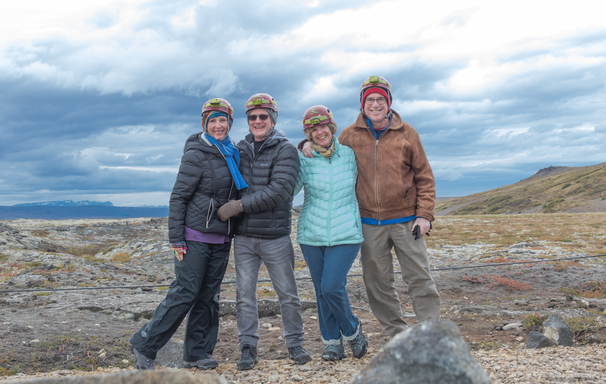
The cave is more than 30 meters underground with assorted ledges and overhangs, so we were first equipped with helmets with mounted flashlights. As you can see from this photo we were ready for some volcanic spelunking.

Iceland Lava Cave 2018-009

The entrance to the cave is suitably maw-like, and we picked our way along the, um, unadventurous wooden stairs and boardwalk, following our guide and listening to his lecture about the geology of the place.

Iceland Lava Cave 2018-019Iceland Lava Cave 2018-023

We are not unfamiliar with lava tubes because of our time in Hawaii, but Víðgelmir is particularly impressive. It’s nearly a mile long and sports a variety of lava formations much more typical of a “conventional” limestone cave, e.g., stalactites and stalagmites, albeit very small ones. But its most (to me) unexpected feature is a consequence of its temperature, which hovers at just about freezing. Consequently there are a large number of crystalline stalagmite-like ice formations like these.

Iceland Lava Cave 2018-037

Iceland Lava Cave 2018-033

I found them particularly otherwordly. And indeed, if you get too close they break open and this thing that looks like a horseshoe crab jumps out and grabs your face, and you just know what’s gonna happen after that.

The cave tour lasted about an hour and a half, and we set out to our next destination, the Barnafoss and Hraunfossar waterfalls, adjacent to each other along a short looping walking path. They’re beautiful and would have made a great venue for a drone flight except that by this time the rain had started in earnest.  Hraunfossar — the name means “lava falls” — has an unusual property: its water seems to come out of nowhere. What actually happens is that the glacial melt percolates through the surrounding lava field and emerges as a line of cataracts along the river; indeed, you can actually see the water coming out of the rock. Take a look:

Iceland Barnafoss 2018-006

Barnafoss, only about 200 meters away, means “Child Falls”, named after a rather dreary local legend about them. The story goes that one day two boys, home alone while their parents went to church, got bored and decide to follow.  (The assertion that two young boys spontaneously decided to go to church on their own tells you immediately that this is a myth.)  Anyway, the legend tells that they tried to take a shortcut over a natural stone bridge that crossed the falls, but fell off the bridge and drowned. The mother of the boys then cursed the bridge, and shortly afterward it was destroyed by an earthquake. This is about as cheerful as Icelandic legends get. It must be the weather. In any case, here’s Barnafoss:

Iceland Barnafoss 2018-013

You can tell from the photos how gray the sky had gotten, and in fact it was pretty much pouring by this time. So we gawked until satisfied, then retreated to the car and returned to Borganes. Our lodgings are an AirBnb, a very pleasant two-bedroom cottage overlooking the fjord. Borganes has a population of only about 3,000 but I am happy to report that we were able to satisfy Janet’s craving for pizza: there are at least two pizzerias in town, and the one we chose was excellent.

Tomorrow: further into the frozen north!


Categories: Europe, Iceland | Tags: , , , , , , , , , , , , , , , , , , , , , | 3 Comments

Hapuna a me ka Lapakahi

…which is not as complicated as it looks. It simply means “Hapuna and Lapakahi” in Hawaii, those being the names of two places on the Big Island that we visited yesterday.

Hapuna Beach is one of the best known beaches on the island, an achingly photogenic stretch of dun-colored sand caressed by a gentle turquoise surf, and framed by two jagged lava promontories at either end. Here’s a panorama from the drone, taken during yesterday’s visit:

Hapuna Beach drone-001

Besides the obvious beach and surf, there are two other features of note: Kohala mountain bulging gently above the horizon at left, and the luxurious Hapuna Prince Beach Hotel at far left, regally overlooking the scene. The hotel is enormous and beautiful; several years ago we had the privilege of staying there for four or five days on someone else’s dime while attending a boondoggle conference. The mountain is also enormous: a mile-high, 200 square mile (500 square km) extinct volcano that essentially is the entire northwest corner of the Big Island.

Conditions are not always this idyllic at Hapuna. The surf can be rough, although the bottom is sandy — unlike the other, rockier beaches on the island — and so a rough surf is far less dangerous than elsewhere. And if the wind is high you can get sandblasted whilst attempting to enjoy yourself. But these are the exceptions. Most frequently the place looks like a postcard and it is a popular destination for sunning and body surfing. Here’s a 2-minute drone flyover video to give you a sense of the place:

(As you can tell, I’ve gotten heavily into flying my drone on this trip. But I dare you to tell me that this is not seriously cool.)

Neither Alice nor I are sunbather types. For one thing, when I am in strong sunlight my mottled pasty complexion moves the state of my skin almost instantly from “Anemic Vampire” to “Crimson Crispy”. In the words of Woody Allen, “I don’t tan, I stroke.” And Alice grew up in Oregon, where one’s best opportunity to get a tan requires dodging the raindrops. So we hung out for 45 or minutes or so with our visiting friends, then moved on.

Our next stop, further up the coast in Kohala, was a little more cerebral: Lapakahi State Historical Park. It’s the ruins of an ancient coastal village, about 600 years old. The name means “single ridge” and it is an array of ruins and reconstructed structures spread out along a rough lava coast and threaded by a mile-long interpretive trail. Like so many archaelogical sites it seems to make the most sense when viewed from above, so here are a couple of aerial shots:

Lapakahi drone-002Lapakahi drone-001

In addition to the ruins, the offshore area is a Marine Life Conservation District. The interpretive path takes you past a variety of structures in various stages of deterioration or, in some cases, reconstruction. There are dwellings, canoe storage houses, salt-making pans, and a couple of kōnane games, the latter being a lot like Chinese checkers. It’s played on a lava “board” with a grid of hollowed out pits, with alternating black and white stones placed in the pits and variously moved around per the rules.

The aerial views give you a sense of the layout of the place, but, truth to tell, when you are following the path it mostly feels like you are walking among a random collection of low lava walls of uncertain purpose. Which, I suppose, is why I am not an archaeologist. Nonetheless, the place has an enjoyably eldritch feel to it, the susurration of the surf and the dark rough lava walls invoking a real sense of mystery and age. Or to put it another way, it feels just a bit like being inside the beautiful old computer game Myst. Here’s a video that I took by flying along the coast, so that you can see how large and spread out it is.

The surf has been high and the weather on the windward (eastern) side of the island rainy for the past few days, so we have confined our roamings to the Kona coast and the western side of Kohala to escape it. But things look better for the next few days. Tomorrow we will try and make it to the 13,802′ (4205 m) summit of Mauna Kea where the conditions are expected to be clear, provided one is willing to tolerate sub-freezing temperatures and 20 mph winds. They’ve had a lot of snow up there this winter, so if we are lucky then I will have some “snow in Hawaii” photos to post.


Categories: Hawaii | Tags: , , , , , , , , , , , , , , , , , , , , , | 2 Comments

Waipio? Wai not?

The oldest part of the Big Island is its northwestern corner, a 15 mile (25 km) long, 10 mile (16 km) wide peninsula called Kohala. It is, in fact, a single giant extinct volcano, the first part of the island that formed. That makes it about a million years old, and it last erupted about 120,000 years ago. So it’s old; eroded and overgrown, it’s now cattle grazing country, a huge grassy hill dotted with overgrown volcanic cinder cones and commanding a view down the coast.

When the clouds are not in the way — which they are, more often than not — you can see Mauna Kea and Mauna Loa as well.  Today we had — what is for this part of the island — uncharacteristically beautiful weather; the day was clear and warm, though distant clouds kept Mauna Kea out of view most of the time.

At the southeastern end of the peninsula, on the windward side where Kohala joins the rest of the island, is one of the Big Island’s most paradisaical  locales: Waipi’o Valley. A 1000-foot deep, half-mile wide slash in the lava-stone coastline, Waipi’o’s striking appearance is matched by its comparable inaccessibility. It was the home of ancient Hawaiian chiefs and is still considered a “cultural seedbank”, dotted with taro fields and threaded by a shallow river that flows down to a black sand beach. The nearly vertical green walls are punctuated by waterfalls, giving the place a serene Edenic feel. I wrote about it a year ago in this blog post.

It’s tough to get down to the bottom: you need a good four-wheel drive or really strong thighs and cardiovascular system to tackle the intimidating 25% grade. We did it for fun when I lived here, 35 years ago; today I sent a drone in my place.

The cranky “Resource Ranger” (that’s what it said on his name tag) wouldn’t let me launch the drone from the lookout point and admonished that I must not fly into the valley at all. So I walked a few hundred yards back down the approach road and launched from there instead, being careful to stay out over the water and above the rim of the valley. Here’s what it looked like from my airborne proxy, nearly 500 meters above the beach.

If you’d like a greater sense of immediacy about the place, here’s the video from the same drone flight:

Categories: Hawaii | Tags: , , , , , , , , , , , , , , , , , , , , , , | 3 Comments

Kayaking at the End of the World

That’s “End of the World” as in that part of the Kona coastline, not the apocalypse sort. And we weren’t the ones doing the kayaking. And…oh never mind, you’ll see in a moment.

We are enjoying a brief visit from our friends Laura and Brian, who live in Honolulu and whom we usually stay with for a few days during our sojourns here. This time they came to us on the Big Island. Laura is one of my oldest friends, dating back a terrifying 46 years or so, a nice Jewish girl from Massachusetts who fulfilled the lifetime dream of all nice Jewish girls by marrying a Hawaiian. (For the record, poi is kosher, Kahlua pig isn’t. Not that she cares either way.)

We took them down to End of the World this morning to be appropriately awed by the  gigantic crashing waves there, only to find a disappointingly calm sea. However, those ocean conditions were a lot better received by a large group of kayakers, college students from Georgia who are here on some kind of Outward Bound-type of program. I know this because I felt obliged to buzz them with the drone, which prompted an unexpected visit from their tour leader: he walked over to us from the top of the cliff overlooking the kayakers to gawk at the drone, explain who they were and — to my surprise and delight — ask if he could purchase my drone photos and video footage for their publicity material. Being a nice guy and an idiot, I gave them to him for free. Here are a couple of the shots.

Having acquired that smidgen of good karma, we moved on to our next destination: Naalehu, at 19.07° latitude the southernmost town in the U.S.  It’s a sleepy little place where every single business establishment correctly if rather repetitively advertises itself as the Southernmost ______ In The United States; you can fill in the blank with restaurant, barber shop, gas station, funeral home, or whatever. Our particular target was the Punalu’u bakery, which is the southernmost et cetera et cetera.  I wrote about Naalehu and Punaluu in this blog post two years ago, so you can read it and brush up on the details. (Clicking the link will open the post in a new browser tab so you won’t lose your place here.) Punalu’s big attraction is their malasadas, a jelly-donut-like confection of Portuguese origin that will transport you to heaven both figuratively (because of the taste) and literally (because of the calories and cholesterol).

Having pushed our LDL numbers into a blissfully unhealthy range, we moved on to South Point, the actual physical southernmost point in the U.S. at latitude 18.91°. It’s a windswept volcanic coast of lava cliffs overlooking crystal cerulean waters where you can see the coral reefs all the way to the bottom. The actual location is signified by a navigation marker, as you can see here.

The “windswept” part gave me pause, since my drone gets unhappy when the winds reach about 20 mph (32 kph) and I was a little nervous about the thing blowing out to sea. But it handled the conditions without much difficulty, affording me the shot of the navigation marker and this view of the coastline.

One of the bizarrely popular activities on those cliffs is cliff diving, a sport in which I have no desire to participate. There are several metal ladders drilled into the lava at the top of the cliffs near where the cars are parked, so that those daredevils who do take the plunge — invariably testosterone-besotted young males — can climb back up in safety rather than, um, die.

You can tell from the photos that outside of the cliffs themselves the terrain is rolling grassland. Indeed, as you navigate the one-and-a-half lane road south from Naalehu for 12 miles to reach South Point, you pass a number of cattle farms that look like they’d be right at home in the higher elevation cattle ranches on the northern part of the island, or for that matter in Wyoming.

The wind is pretty constant, the trade winds rounding the point as they blow from the northeast. And so it is not at all surprising that the region takes advantage of that with a wind farm, dramatically situated on a ridge as though commanding the seas whilst harnessing the breeze.

 It was about an hour trip home from South Point, where we crashed for a few hours before continuing in the sacred tradition of Eating Too Much While On Vacation. Dinner was at Annie’s, a cheery low-key place overlooking the ocean and billing itself as proffering the best hamburgers on the island. Make a note of that if you come here: they make a pretty strong case for the claim.


Categories: Hawaii | Tags: , , , , , , , , , , , , , , , , , , , , , , , , , , | 1 Comment

Blog at WordPress.com.